A brief history of Eritrea
Eritrea, officially the State of Eritrea (Tigrinya: ሃገረ ኤርትራ, Hagere Ertra, Arabic: دولة إرتريا, Dawlat Iritriyya), is a country in eastern Africa. It borders Sudan to the northwest, Ethiopia to the south, Djibouti to the southeast, and the Red Sea to the east and northeast. It has been a province of Ethiopia for several decades. The country has been independent since 1991 and was recognized as an independent country by the UN in 1993. Tensions between the two countries dominated the first decades after independence, sometimes in the form of armed conflict.
At Buya in Eritrea, one of the oldest hominids was found by Italian scientists, which would indicate a link between Homo erectus and Homo sapiens and is over one million years old. Later, several tools were also found south of Massawa that are said to be more than one hundred and twenty-five thousand years old. During the last interglacial period, the coast of the Red Sea near Eritrea was inhabited by modern humans. Some scholars suggest that this route was used to colonize the rest of the Old World from Africa. According to linguists, the first people of Euro-Asian descent would have moved into the region during the Neolithic period (from 11,000 BC), probably from the Nile Valley or the Middle East.
Along with Djibouti, northern Somalia, and Sudan, Eritrea is considered the most likely location considered by the Ancient Egyptians to be the land of Punt. The first references to this land date back to 2500 BC. The Puntites had close ties with the Egyptians during the reign of Pharaoh Sahure and Queen Hatshepsut. The area was also referred to as the place where the Ark of the Covenant would have ended up after its disappearance. Eritrea is also said to have been the home of the Queen of Sheba.
Excavations at Sembel show that an important culture, the Ona, was established in Eritrea between 800 and 400 BC. The people of the country formed the first herd farming communities in the Horn of Africa. Foundings in and around Agordat indicate the presence of the Gash.
The Aksum Kingdom existed from roughly AD 100 to 940. The Aksumites first settled in the highlands of the Ethiopian plateau and moved further and further south from there. It is unclear where they came from exactly. In 615, during the lifetime of the prophet Muhammad, King Armah hosted some of the first Muslims from Mecca, who suffered persecution there. Aksum is said to have played an important role in the ivory trade and an important part of the trade passed through the port city of Adulis.
Aksum would also extend his rule northwards into the territory of what is now Sudan. This was at the expense of the kingdom of Kush. Himyar, in present-day Yemen, was taken in the Arabian Peninsula around the beginning of the 3rd century. It is unclear how long Aksum’s exact presence there lasted. Over time, the empire’s northern border shifted upward, so that Aksum at one point bordered the Roman province of Roman and Byzantine Egypt.
After the decline and eventual demise of Aksum in the 10th century, the area came under the control of the Negus, or the various Ethiopian kings. The area was named Ma’ikele Bahr. In other words, the area between the two rivers, a reference to the Red Sea to the east and the Mareb River to the west.
The Ottoman Empire made several attempts to advance further inland after conquering much of the coastal strip in the 16th century, but they later disappeared from the scene.
Eritrea was already governed by many powers when it was colonized by Italy in 1885. Italian Eritrea remained in Italian possession until 1941 when Italian troops were expelled from the area by the Allies and became a British protectorate. Until 1943, the Italians in Eritrea still waged a guerrilla struggle against the British.
In 1950, the United Nations decided that Eritrea would become part of a federation with Ethiopia. The federation was launched on December 2 of that year. Eritrea got its own parliament and civil service. Delegates from Eritrea also obtained membership of the Parliament of Ethiopia. In 1961 the federation was dissolved by Emperor Haile Selassie of Ethiopia. Many in Eritrea disagreed and many protests followed, especially from students. In 1962 the Eritrean Parliament was abolished and Eritrea was made the fourteenth province of Ethiopia by the emperor. However, by then the Eritrean War of Independence had already started: in September 1961 the Eritrean Liberation Front (ELF) took up arms against the Ethiopian government. In 1971, the Eritrean People’s Liberation Front (EPLF) broke away from the ELF. Twice these groups went to war, after which the EPLF emerged as the strongest.
In 1991 the war ended with a victory of the Eritrean rebels over the Ethiopian government army. In 1993 a large majority of the population voted for independence. Since then, Isaias Afewerki has been president of Eritrea. The Popular Front for Democracy and Justice (PFDJ), founded in 1994, became the only allowed party.
In 1998 a new border war with Ethiopia broke out (the Eritrean-Ethiopian War), which ended on December 12, 2000. A United Nations Peacekeeping Force (UNMEE) was stationed in the border area from 2000 to 2008, pending the final determination of the course of the border between the two countries by an international commission. Ethiopia rejected the commission’s proposal. Since then, there has been a fragile peace.
At the end of 2020, Eritrea became indirectly involved in the War in Tigray, the northern region of neighboring Ethiopia.
Demographics
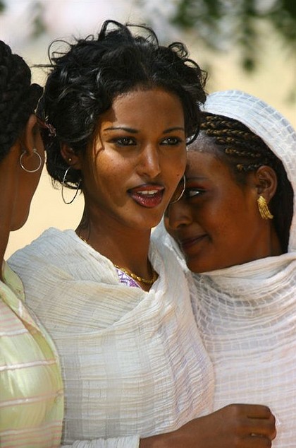
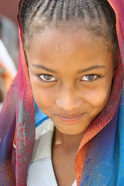
The inhabitants of Eritrea can be divided into nine nations; the Tigrinya, the Tigre, the Afar, the Saho, the Kunama, the Nara, the Bilin, the Hedareb, and the Rashaida. The Tigrinya are the largest in number.
In Eritrea, the two predominant religions are Christianity and Islam. About 50% of the population is Christian, divided between the Eritrean Orthodox Church, the local Oriental Orthodox Church and various smaller groups such as Roman Catholics, Protestants and others. The group with the largest Christian following is the Tigrinya (the percentage of Christians among them is 95.6%). The remaining 50% of the population is Muslim, mostly Sunni. The Saho, the Rashaida and the Afar are mostly Muslim.
Language
Eritrea has no official language. At school, children are taught from an early age in Tigrinya, the language of the Tigrinya people, which uses the syllable script Ge’ez. Other peoples, for example the Tigre, use Arabic. Both peoples also use English. English is the language of instruction in secondary and university education. Especially the older and highly educated people in Eritrea still speak Italian, because of the former colonization of Eritrea by Italy.
Geography
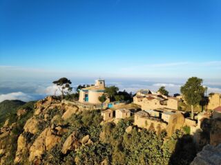
The relief of Eritrea is dominated by the foothills of the Ethiopian Highlands to the north and a desert plain descending to the east. In the northwest we have hilly terrain and in the southeast plains. The country has a high central plateau that ranges from 1.800 to 3.000 meters above sea level. The rest of Eritrea consists of coastal plains, western lowlands and some 300 islands. Asmara, the capital, is located approximately 2.400 meters above sea level. Eritrea has a total of 1.630 km of land borders, of which 113 km with Djibouti, 912 km with Ethiopia and 605 km with Sudan. In addition, it has a coastline of 2.234 km, of which 1.151 km along the mainland and 1.083 km around the islands in the Red Sea. The highest point of Eritrea is the peak of Mount Soira at 3,018 meters above sea level. The lowest point is near Kulul in the Danakil Depression.
Economy and doing business in Eritrea
Eritrea’s natural resources are gold, diamond, potash, zinc, copper, salt, possibly petroleum and natural gas. In addition, fishing is important.
The land is used in the following way:
– Buildable land: 12%
– Permanent crops: 1%
– Permanent pastures: 49%
– Forests: 6%
– Rest: 32%
– 280 km² of the land is irrigated.
Eritrea’s GDP is estimated to be 2.1 billion in 2020 and grew 3.9 percent for the last ten years, mostly due to mining and cement production. Worker remittances from abroad make up 32 percent of gross domestic product. Eritrea is ranked 189 out of 190 for ease of doing business in the whole world. Because of all the bureaucracy it’s hard to get permits to do anything, even to construct or get connected to the electricity network. Furthermore it’s hard to get money in or outside the country, cross borders or even use the internet.
Climate
Eritrea is dubbed as the land where you can experience three seasons in just two hours: from the cold mountains of Emba Soira to the hot desert of the Danakil Depression to the cool breeze of the coast.
Asmara is located at 2.300 meter above sea level with a pleasant climate all year long and the eastern coast gets some rain from October to March, while the other regions get bigger rain showers between June and September. Deeper inland into the mountains we get temperatures up to 30° in May-June and from December to February temperatures can reach 0° at night.
The coast can get very hot from June to September with temperatures over 40° so it’s not advisable to visit this area during this period. It’s better to visit during the rainy season with pleasant temperatures between 20° and 25°. The rest of the country can be visited around the year.
Be sure to bring a warm sweater and a jacket and long pants if you go to Asmara and the mountains and to bring sunscreen, sunglasses and a hat for when you visit the coast and other areas. Remember that you’re in Africa and people dress more conservatively and put effort in the way they look. It’s advised to look sharp when going to a restaurant and bar and leave the shorts and tops for the hotel pools and beaches.